Thursday, May 5, 2016

Dismal Key: One Very Different Island Among Ten Thousand

25, 53, 34.37 N.
  81, 33, 35.00 W. 
A little too far to kayak for a day trip, we did this adventure in a 14 foot Boston Whaler
Its been more than a year since my last gunkholing post but you shouldn't think I haven't been doing anything.  There are now two related books out there: a revised, updated and illustrated version of my original Kindle title now in paperback, REACH YOUR PERFECT BEACH IN AND AROUND NAPLES FLORIDA which was published in May of 2015.  A well received book of funny animal stories gleaned from my years as a beach tram driver at Clam Pass Park was published in December.  It's called  A FUNNY THING HAPPENED ON THE WAY TO THE BEACH: Tall True Tales of Zany Animals and Crazy People Making Mayhem in the Mangroves of Florida.  Both titles can be found at Amazon or in the Conservancy of Southwest Florida's gift store.  BEACH GUIDE BOOKMAYHEM IN THE MANGROVES You'd be correct though in thinking that I haven't been out there in the Ten Thousand Islands or the Bahamas or the Everglades or the Caribbean searching for blog fodder.  I came within a hair's breadth of scoring a crew position on a sailing trip through the Panama Canal with a stop-over in the Kuna Islands before heading back to Key West.  We might have harvested some really interesting blog fodder about the Kuna Tribe, but the wife of the boat's skipper decided to stay on the west coast for the time being.  
     I've been obsessively focused on a particular Key to explore for some time and wanted to explore it and write about it next, even though there were a number of logistical challenges, not the least of which was the lack of a proper boat.  Indeed we'd been on it once briefly when my friend and former lunar-lander scientist Captain John told me about an Indian Shell Mound he knew about and took me there on a whim one afternoon while we were fishing off Jackfish Key.  We were in shorts and sandals and had no cameras with us, so I had always wanted to return properly dressed and record it.  At the time, I didn't know this little island was famous in its own way and it seemed just a very interesting anomaly among so many islands.   In the meantime, I read up on it and discovered that at one time it had rattlesnakes on it which didn't provide me with a big incentive to rush to return.  It took me a year to bum a boat ride (you might recall that but for a couple of kayaks I am currently boatless), which is not as bad as being homeless but emotes a similar feeling of "lessness" in me at least.  
     Professional photographer and fellow sailor Jim Freeman has a small Boston Whaler and he came through for me in early April of 2016.  I felt obligated to warn him about the rattlesnakes which he blew off as a non-issue as he was raised in west Texas.  I brought a long a machete ostensibly to use on cacti but I always had the rattlers in the back of my mind.  I was not raised in west Texas, though I do own a pair of expensive Tony Lama's rattlesnake-skin boots and the bad karma of that concerned me in this instance. I briefly considered wearing them but then decided against it as it just might really piss them off. 
     These days Jim lives in a beautifully appointed home on the water in Goodland which while located on Marco Island is totally distinct from it.  The little town is a throwback to another era where residences are of many descriptions and each dwelling has a boat of every description in the backyard.  There is still a thriving commercial fishing fleet with a fresh seafood market and the smell of gunk in the air.  On April 10th the weather was absolutely perfect and as it happened Jim was available and I had the day off from my new encore career as a crossing guard for financially-secure seniors.  Not only was I able to persuade him to take me out there and back for beer and gas, he let me use all of these terrific and unusual photo's of his.  I deliberately left my still camera home so as to not "mess with the master" but I did bring the video camera.  Here's a link to Jim Freeman's site.  Jim Freeman Photographer .  If you clicked on it, you'll understand why I left my camera at home. 
    

Despite precautions we were pulling itty bits of these out of my skin for a few days afterwards
 
My first awareness of Dismal Key was from Carl Hiaasen's 2006 novel NATURE GIRL where a bunch of really bad guys try to do some nasty things to a really nice girl in a kayak.  As are all Hiaasen books this one is a real "Hoot".  The whole island is 17 feet above sea level and comprised almost entirely of ancient oyster shells.  So the mound is not a hill per se, but rather the entire island is elevated and since the rainwater percolates through the shells to the original dirt about 15 feet below, the top surface is as dry as a desert and cacti abound.  It is literally a desert island in Florida and as you can see in the aerial photo below (which I downloaded from America.pink) there are about ten of these oyster shell fields on the island.  Wikipedia posits that this particular shell mound dates anywhere from 950 AD to 1450 AD and represents the Glades Culture which later was usurped by the Calusa Tribe who like many other native tribes did not survive the ultimate European Invasion.   By the mid 1500's this area was administered out of Havana.  If you would like to know more about the history of the island, click here.  Wiki Link
     It is worth noting that this place is less than 15 miles from the site where the famous "Key Marco Cat" was dug out of a pond.  This cat is on display at the Smithsonian and is roughly dated from the same period. 
Aerial of Dismal Key from America.pink

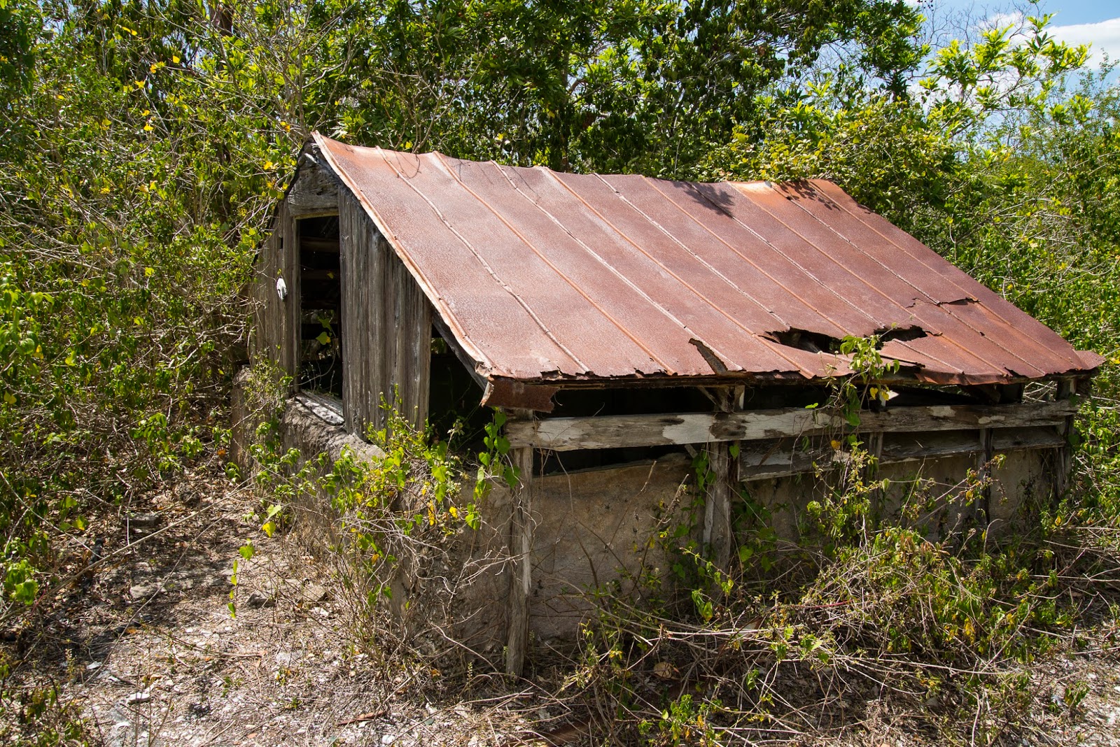
In case it crossed your mind (as it did mine) to try and get a cat of your own please be aware that it is illegal to dig for artifacts on this site or others like it.  In fact, it is part of the plot of Hiaasen's NATURE GIRL where the bad guys bring in heavy equipment to move the shells to find the treasures.  Illegal or not, it does appear that someone did not get the memo and started digging a hole here.  More recent artifacts abound a plenty though.  They are interesting in their own way as from the early 1900's until 1992 a succession of hermits occupied this island and left their own evidence behind. 
Illegal Dig
 
By definition, two people living together on an otherwise deserted desert island wouldn't be hermits.   Apparently in the hermit hierarchy, the one on Dismal Key was the Alpha Dog.  The others would keep an eye on this hermit and when he moved on or died, the next one would be all ready to move-in and inherit his stuff which included a hut, an outhouse, a cistern and fine glassware.   Apparently one fellow lived on Panther Key nearby and coveted the facilities on Dismal Key to such an extent that he jumped at the relocation opportunity when the chance presented itself.  If you want to read more about the hermits of Dismal Key, I found this article from 1992 in a Seattle Times archive of all places.  Here's the link Seattle Times Hermit Story.  There is more information about the hermits out there if you just "Google it" including an interesting blog from a descendant of the last hermit of Dismal Key.   
 
The Cistern


White Man's Trash
 
Cecil B. DeGunkholer
Native American Trash; Thousand Year Old Whelks on Oysters

Dismal Key Video on YouTube

Friday, March 27, 2015

Aargh! Here lies Rocky Rockford and thereby lies a tale!


ROCKY ROCKFORD
BEST FRIEND & FIRST MATE
MAY YOU FOREVER ROAM THE BEACHES & FISH
9/19/03 - 6/9/12
M/V INVICTUS
My first experience as a "blue water" sailor came about as a result of a Reddit post, about a month after my 65th birthday.  After a hair raising 72 hours at sea between St. Thomas and Grand Turk, half of which was spent in darkness in a series of two dozen "three-on, three-off" watches many of which were in  gale force winds and 15 foot seas,  the crew of the Okoume was in need of some serious shore leave.  There was only one crew member (your narrator) but the owner/skipper of the 41 foot Lagoon catamaran was a former Army Ranger who saw better at night than I did in daylight, so counted as three more, though he only stood his own watch.  After recuperating for two days in Grand Turk, immediately adjacent to the cruise ship dock and not really able to get much significant repair done there due to a lack of facilities or a chandlery, we did another 48 hours "three-on, three-off" straight through to San Salvador.  After a mile walk to the local airport, we cleared Customs and Immigration and the skipper paid our hefty $300 entrance fee to the Bahamas.   It was here at the Riding Rock Marina where an American sailor from the Carolina's who was cruising to the Dominican Republic, told us about a neat anchorage called Booby Cay.   I am not sure what you are thinking but it is likely named after the seabird with the funky feet.


Booby Cay anchorage is one of a small handful of bays at Conception Island, a national park in the Bahamas of which I had never before heard.  It is about 37 miles west of San Salvador and would have represented my most perfect 'REACH YOUR PERFECT BEACH" moment in its own right, even without the skipper's serendipitous discovery of Rocky's remains.  As a result of this discovery, it now ranks up there with the best gunkhole adventure of all time as well.  Upon research, I discovered this "Conception Island is a national park with no inhabitants or facilities. Anchoring and landing is permitted but absolutely nothing must be taken or left."  Duh, somebody certainly left something behind here.  This blog has been germinating for a quite a few months on the backburner of my mind and for a while I considered not writing it all, in order to preserve the peace of Rocky's final resting place.  It is nowhere near a beaten path and if my skipper hadn't been a Viet Nam era Green Beret who for nostalgic reasons loves to trudge through jungles, then likely it would be undiscovered still. 

We assumed that Rocky was a grizzled old limey Salt who was 109 years old when interred here though upon reflection, given the dates on the inscription he could have been 9 years old.  We are going with the former as it is unlikely that he could have found a such a loyal friend who would schlep his remains to such a forbidding and inconvenient resting place in such a short span of friendship nor was he likely to have crewed on a motor vessel at such a tender age, except perhaps as a cabin boy. 

I began my research on the ship, as I thought a majesty's vessel of such a distinctive name would be easy to find with maybe a crew list appended.  Perhaps we'd find a glamorous Royal Navy destroyer in the Hood class which was among those that sank the Bismarck.  But it soon became apparent that M/V and HMS were two distinctively different prefixes and that the former was much less glamorous than the latter.  I was surprised to find that the Royal Navy had never named a ship HMS INVICTUS.  It seemed to me that the name would have ranked right up there with HMS VICTORY or HMS INVINCIBLE.  There is a fabulous luxury yacht of that name but it is of recent vintage and so it is unlikely that Rocky might have crewed on it, unless as a nonagenarian cabin boy.


INVICTUS of course is the name of a 19th century noble English poem by William Ernest Henley that is associated with Nelson Mandela and contains the well known inspirational lines "I am the master of my fate.  I am the captain of my soul".  It would indeed be a noble ship that bore such a noble name in a noble cause, you would think, and Rocky on his perpetual royal Bahamian private perch would likely be a noble character.  Then I discovered this.Trinidad Express

It does seem quite plausible and even likely that this was Rocky's ship and these were Rocky's mates that gave him this wonderful resting place. The kind of guys that smuggle diesel fuel in fish holds would likely not feel too bound by run of the mill Parks and Recreation rules. "Well done, Rocky's mates".   Conception Island Video

A couple of comments with respect to the video.  I have an old hardcover book from the 1970's that is a cruising guide to the Bahamas and the Caribbean, which I had foolishly left at home.  The mast/antenna in the video is identified on a sketch map of the island as a light during that era.  The footprints in the sand are my own from the previous afternoon when I did some preliminary scouting and I truly hope no-one else ever finds Rocky's marker. 

I have been lax in my blogging, but have an excuse as I finished the second edition, now illustrated of my first book and will have a black and white paperback version of the same out shortly.  REACH BEACH BOOK AT AMAZON.  The E-Book is in full color.  I am about a third of the way through my second book of non-fiction tentatively called A FUNNY THING HAPPENED ON THE WAY TO THE BEACH, which is comprised of light hearted nature stories that occurred over my nearly ten years on the Clam Pass Park boardwalk.  I am hoping to have a talented local artist illustrate it with line drawings for me.  Reluctantly I have made some changes in my life.  I gave up full time Tram Driving in favor of part-time seasonal work as security personnel at Pelican Bay.  When season ends in a month or so I hope t have more time to write and explore.  Also, with great regret I sold my beloved Gertie the Gheenoe and am currently between boats.  The sailing trip about which more blogs are to follow, has me thinking about whether to continue sailing or like Rocky Rockford, just go fish.  Thank you for reading and your continued support and encouragement.  It is spring up north and summer is soon to follow.  I hope you can REACH YOUR PERFECT BEACH this year. 

Wednesday, November 19, 2014

The Skull and Bone of Kice Island


My assistant gunkholer, (daughter Lauren of Islamorada Fish Company fame) came down from Chicago at the beginning of October with some romantic notion that camping out on the beach would be a really cool thing to do for my birthday.  The weather was ideal and I remarked that "if we were ever going to do it, then this was the time to do it".  It crossed my mind too, that this would provide a perfect opportunity to try and find some whale bones from that large pod of pilot whales that beached itself this past winter, as referenced in our previous Cape Romano Dome Houses blog.  I too had a romantic notion that if a significant amount of whale bone was found, one could always take up scrimshaw in retirement, a far more glamorous pursuit for grizzled old salts than, say crochet or crosswords. 

It took some cajoling on her part to convince me that the "insect season" was over as the air temperature was still in the 80's and the high summer humidity lingered.  Additionally, as a newly minted Medicare recipient, I was not particularly fond of the idea of testing this particular federal benefit on the first day of issue with the aching bones and rickety back that was surely to be the outcome of a night spent on the hard ground among the sandspurs. 

Florida among many places has these little biting midges colloquially called No See-ums that are as annoying as heck and the only thing that seems to work on them is repellent that has a significant percentage of DEET in it.  It was my 65th birthday and I had never camped out on the sand of a beach (I have slept in the cabin of a boat) and while it didn't merit a place on my bucket list, I felt that it was something that any Gunkholer worth his or her "salt" ought to do.  So we worked it out.  We planned to sleep at Blind Pass where it enters the Gulf of Mexico, a couple of miles north of the Cape Romano Dome houses, the subject of our previous blog.  It would have been a very easy trip from the Caxambas Pass county boat launch, but a sign there prohibited overnight parking.  A phone call later to someone with local knowledge, caused us to divert to Goodland, at the southeast corner of Marco Island where for an additional fee we were able to park our car and trailer overnight.   This was not my first choice because this route has a lot of exposed open ocean to the south which is not a good place for Gertie to be most times with just six inches of freeboard and never a place for her to be in a southerly blow especially with two adults and a load of camping gear.  Additionally it is far longer than the alternative as you can see from the yellow line on the map above causing us to use more fuel than I had accounted for.  Luckily the easterly wind was modest and our trip out was uneventful and on arrival at the western mouth we were greeted by the smoothest Gulf of Mexico water I had ever seen.  Wind and weather can be quite fickle so we chose not to take the time to unpack and just headed north.  I had forgotten my binoculars but expected that a mass of 10 or 20 whale ribcages would be easy to spot from 30 or 40 yards out in the water.  Turned out I was wrong about that and never did see one skeleton from offshore.   The longer trip from Goodland had consumed all the fuel in the Nissan's small internal tank.  As the motor sputtered to a halt, we approached the shore among standing deadwood and submerged stumps to refill it from the spare fuel can while on the shell beach.  I looked down and there right in front of me was a rib bone from a whale.  Yes, one bone.  Now what are the odds of that?  Having embarked from a last minute choice of an alternate port which was going to require more fuel, we run out of gas right at the spot of a single bone? The feeling was uncanny and I continue to think something else was at work here, as had we embarked from Caxambas Pass our initial run would have been from the north (see the top of the red line on the map) and we would not have run out of gas at all. 
Not only that but Lauren looked up the shore to the north and exclaimed "Whoaa!  Look at that" and there, just a few yards away lay a huge skull of a whale.
We refilled the fuel tank and not seeing any bones in the immediate vicinity decided to head up the coast another mile or so to try and discover some more.  When we got to the north end of the island without finding any, we pulled up on the big beach to regroup and then shot this video on the trip south.  At 2 minutes and 14 seconds it seems a little long in retrospect, but stick with it as the skull discovery is the last 43 seconds of it and besides it is a rare view of Kice Island that most people are never going to see under these ideal conditions.  Kice is a special place with 4,000 acres of mangroves and absolutely no development and exists only as a result of a special deal negotiated with Deltona Corporation (the developers of Marco Island) to be kept forever green in exchange for the right of the developer to make Marco Island forever paved.  During the first part of the video where I shout "WooHoo" we scattered a large school of mullet.  Gunkhole Gertie southbound off Kice Island FL
Assuming my best National Geographic paleontologist's pose so as to trick my grandson into thinking I had actually discovered a dinosaur, Lauren snapped this terrific picture above.  Mission accomplished we continued down to Blind Pass and sought a campsite.  It was a full moon tide cycle which means that the normal tidal amplitudes in flood and ebb are magnified.  That is if a normal tidal differential is 2 feet, then during the full moon it might be three feet or four.  Thus we set up the tent high on the dune line, well above the previous high tide line, though that unfortunately set us well inside the sandspur line.  It was a borrowed tent and neither of us had ever tried to set it up before.  Needless to say that was bit of a challenge and things got a little testy here and there but in the end this is what we ended up with, and yes we did have parts left over, but apparently they were spares or something. 


Saturday, February 1, 2014

Cape Romano Dome Houses

This past holiday season, my daughter Lauren who was with me on our first blogged trip in the spring of '13 at Islamorada in the Florida Keys made it clear that in addition to all the usual holiday stuff she wanted to do an island adventure with Gertie and Bernie before she returned to the nasty weather in Chicago.  Rightly so as it turns out.  Lauren lives on the shore of Lake Michigan and it has been reported that record low temperatures there this January exceeded even those of the South Pole.  We can blame it on Canada or Global Warming, whichever floats your boat. 

Lauren was thirteen when she and her sister Vanessa accompanied me on her first independent Gunkhole adventure which was a 150 mile round trip to the mouth of Catskill Creek NY on the Hudson River in our Catalina 22 sailboat.  We "putt-putted" against the strong north wind and the current all the way there with our 8 hp Johnson outboard.  In addition to the spectacular scenery, we remember fondly our evening group reading of RIP VAN WINKLE in the town where he woke up 20 years after he went to sleep.

I chose this relatively easy trip just south of Marco and Kice islands which are among the most northerly of the Ten Thousand Islands, because I wanted her to see something special...the infamous Cape Romano Dome Houses. I have made similar trips 3 or 4 times in the past four years in various craft including an Irwin 28 and with and without company.  My son Drew accompanied me on a "Fakawi" trip for Fathers' Day in 2012 during which we towed our Pelican double kayak behind the yet to be named Gheenoe who after a motor makeover eventually became Gertie.  This turned out to be a good thing as we ended up towing the good  for nothing no-name Gheenoe back to Caxambas by using the kayak as the tow vehicle.  We also hitched a ride for a few miles behind a Carolina Skiff and then sailed a bit using a parachute beach blanket for a spinnaker.  Since then, I've invested in a BoatUSA membership which is kind of like a AAA for boats and they provide towing services.  Generally I find that the water, the mudflats and oyster banks and sandbars and inlets (called "Passes" here) are different every time.   They don't call them "shifting sands" for nothing and depending on the wind and the tide, I have used different routes.  As a result, even though the destination may be the same, the trip itself is always different.  As well the passes in and out to the gulf from the various inland rivers and sounds and bays are here today and gone tomorrow.  On a kayak trip to Blind Pass (which divides Kice Island from Cape Romano Island), I was able to explore deep inside the center of Kice where even Gertie couldn't go at low tide. Kice Island is something of a phenomenon.  But for a complicated environmental court settlement in 1982, it would have been bridged over from Marco Island and its two miles of beaches would have been shoulder to shoulder condo's as a twin development of its big brother Marco to the north.  As it is Kice was never platted for development and 4,000 acres are there to share among the osprey, whales, dolphins, manatees, kayakers, shellers, fishermen, commercial jet ski tours and a few odd ball gunkholers.  . 
Bernie at Blind Pass in 2012 in the general vicinity of where 25 dead pilot whales were washed ashore in January 2014.  Local news story on dead pilot whales

Sunday, December 29, 2013

Gertie, the Darryls and Blackbeard's Ghost in Key Largo

Sometimes it just takes a decade or two to put things into perspective.  When making preliminary plans for a gunkhole adventure I often rely on Google Earth by mapping out a route to get an idea of distance primarily for time and fuel consumption calculations.  The retained visual image allows me to form a mental impression of the area.  Later if conditions change, or I lose my chart or GPS (both have happened) the research is reassuring, in the sense that even if most of the islands look alike - that Key at that location should be XYZ Key.  I chose to use the bayside waterfront Hampton Inn at Key Largo as my base, though I would have to launch at the famous Caribbean Club (location for the famous John Huston movie "Key Largo" which starred Humphrey Bogart,  Edward G. Robinson and Lauren Bacall).  These days they have the only boat ramp on the bay side in that general area and they like to exploit that monopoly to the tune of $20.00 for a daily park and launch ticket.  In the narrow Florida Keys which stretch for more than 120 miles and require the crossing of over forty bridges, waterfront properties are designated as either "Bayside" or "Oceanside".  Florida Bay which is a part of the Gulf of Mexico is on the right as you travel south to Key West and the Atlantic Ocean and all of the famous diving reefs, shipwrecks and  lighthouses are on the left.  Where you launch and what kind of vessel you put in matters as it is not always possible to go from one side to the other, except at strategic crossings which are few and far between.  Those accommodating sailboats with tall masts are even fewer and further between.  There is a narrow canal that accommodates boats no more than 14 feet high  called "Adam's Cut" in Key Largo, which takes one into Largo Sound at John Pennekamp State Park from where one can get reasonably priced excursion boats out onto the various reefs.  On a previous dive/snorkel/fish trip about two years ago my son Drew and I took our double Pelican kayak through "The Cut" in a racing tide to no particular purpose other than to see what was on the other side, which as you may recall is the essence of gunkholing.  More about THE CUT

My destination this time around was the Nest Keys in the southeast quadrant of Everglades National Park.  For Gertie this would be a piece of cake at about a 20 mile round trip.  While I had no intention of kayaking all the way there and back, I did want to paddle the surrounding water.  The harness that was rigged up to Gertie's stern cleats had my little blue Mainstream Jazz riding high and dry behind.  Upper Nest Key has one of the few island beaches in Everglades National Park and it is a designated overnight camping area (though one has to reserve a site and pay a fee).  As the REACH YOUR BEACH guy I had to see it just because it was there.  The island is also home to some very unusual and incongruous architecture that rises ten feet above sea level that I had to see for myself.  My routing had Gertie passing very close to a small, shallow body of water completely surrounded by land.  It looks like an atoll and is named Little Buttonwood Sound.  On the map below it is just under Boggy Key.  It seemed that I had heard something about Little Buttonwood Sound before; it looked awfully familiar and for some reason made me think that I had been there before and thereby hangs this tale.
THE INCONGRUOUS ARCHITECTURE OF THE NEST KEYS
 
In February of 1988, six city slickers from New York, Chicago, Toronto, New Orleans and Milwaukee cast off into the wilderness, north and east of Islamorada on a rented houseboat named the "Roger B".  The motley crew comprised Bill Rickman, Kevin McCaffrey, Joe Friedman, Chris Keen, David Schwartz and me.  We were all booksellers and had finished a series of meetings in Miami for the ABA (American Booksellers Association) and most of us were in no rush to return to winter weather.  At the end of the voyage everyone received a souvenir paper chart of the route and the location of the three overnight stops along with a couple of photographs.  When Little Buttonwood Sound tickled my memory I looked around the house and garage to no avail for that souvenir chart of the "Voyage of the Roger B".  I emailed Kevin and within a few days after finding the chart in his storage locker he confirmed that Little Buttonwood Sound was indeed where we had spent our second night on the "Roger B".  From October 1982 until May 1990 the funniest situation comedy on television was simply called "NEWHART" and the lead character was an owner of a small Vermont Inn played by Bob Newhart.  A stand-up comic whose signature act was one sided telephone conversations, he had a long successful run playing a psychiatrist in a previous series a decade earlier.   Most regular characters on the new show such as Tom Poston (the caretaker in the video) were hilarious and among them were three brothers named Larry, Darryl and Darryl.  To appreciate this check out the link.  The Larry, Darryl and Darryl Brothers.  The brothers were somewhat simple to put it mildly and played beautifully to Newhart's signature dead pan style which twenty years before had been introduced by another terrific comedian - Bill Cosby.  "Noah...how long can you tread water?". 
 
After a series of mishaps, misadventures and plain stupid tricks it became clear to the members of the motley crew of the "Roger B" that they had more in common with the Darryls than with Jacques Cousteau and so that is what we called each other for the duration of the voyage and as it turned out for the duration of our lives.  To each other, each of us is his brother Darryl even to this day.  A handful of other Darryl adventures followed this including a pedestrian hike across the Mexican border at Yuma AZ where nocturnal helicopters searching for soggy spined swimmers in the Alamo canal reminded us of the movie Apocalypse Now as Schwartz barbecued his signature rack of rosemary lamb oblivious to the chaos around him.   In addition there was a hike along the ridge of Catalina Island above Avalon and a sail boat charter in the San Juan Islands with a bar run to Friday Harbor. 
 
We loaded up with beer, booze, groceries and cigarettes in Islamorada.  A much greater percentage of people smoked in those days (myself included) and Chris who was from Toronto had Export A's which were right up there in intensity and strength with the Gitanes and Gauloises of France.  Joe Friedman and I soon thereafter quite smoking with the help of a New York psychologist who used hypnotic therapy.  I mention the cigarette pack which was bright, forest green because none of us had navigation instruments and over the next few days the straight edge of the hard pack of Canadian cigarettes became our parallel rule to connect marks on the chart which we gleaned from the red and green navigation markers that mysteriously appeared from time to time. And so was born a new sailor as Kevin wielded the cigarette pack like a surgical instrument and plotted courses that could have taken us to Cartagena if we had let him have his way.  These days Kevin is an award winning documentary filmmaker ... Everything you didn't know you wanted to know about Cajun Food.  He lives 13 1/2 feet below the levee of Lake Pontchartrain and as a result must be the only person in the world to race his J24 past his own rooftop.  Chris drove the boat as he had some experience with power boats on Canadian lakes.  I was strictly a sailboat guy and any engine over 8 horsepower was likely to induce vertigo and blood rushing to my brain.  I was put in charge of music and played the recently released album by Paul Simon called "Graceland" over and over again at loud volume and I still associate "The Boy in the Bubble" with green, milky water, wind, waves, dolphins and Darryls.


We didn't know it then, but we were zigging and zagging and burning cheap gas to no end in and around the Intracoastal Waterway (ICW) that connects Miami to Key West on the "Bayside".   Especially after my recent trip I have no idea how we ever found where we were going, let alone how we found our way back.  In retrospect, since we weren't really going anywhere, it didn't matter much and we got there (which really was no where), which is entirely consistent with the Darryls' theme of the voyage of the "Roger B".   

"It was a slow day
And the sun was beating
On the soldiers by the side of the road"

It is a pleasure to report that on the morning of Tuesday November 19th, 2013, just shy of 26 years later, the water had exactly the same milky green complexion.  As with most sailing yarns, this one could go on and on and I need to cut to the quick.  Toward sunset of the second day out, we entered the calm bay of Little Buttonwood Sound seeking an anchorage for the night,  A very large power yacht was leaving the Bay through the narrow cut at the same time and the Captain shouted across that he had been unable to find a good holding ground for his anchor and thus he was not going to stay the night.  The Darryl's of course had no idea what he meant and confidently thought that was his problem.  When we threw the anchor off the bow, it disappeared in the ground underwater.  BTW, the water wasn't much more than two or three feet deep throughout the sound and one had a clear view to the bottom.  With the anchor out of sight, we knew we were good and proceeded to debate all the big issues of the day, drink some whiskey and beer, play poker and retired to our respective bunks.

When I awoke I knew instinctively that something was wrong.  The tree branches coming in through the windows were an indication as well.  Apparently, we had been blown ashore during the night.  During our orientation for the houseboat rental, the manager (and much of the literature) made it clear that any ingestion of mud into the boat motor would result in fatal damage for which the renters' (read Darryls) would be held liable.  So one's first instinct which was to gun the sucker out of the mangroves was off the table.  I quietly slipped over the stern deck into the water with the hope that I could pull the shallow drafted vessel back out to deeper water before the others awoke and pretend like nothing had happened.  Unfortunately I promptly sunk to my armpits in the white muck.  Luckily I had hold of a line or I might have been like one of those guys going down the pit in those old Tarzan movies.  Always in the back of my mind .

After pulling myself back up on to the deck of the boat and having a discussion with the crew as to our least expensive options we decided to all get in the water and pull the "Roger B" out of the mangroves.  Though six of us hauling a line over our shoulders like Volga boatmen ought to have resulted in some advantage none of us could get a purchase in the mud and we were not able to move the boat even an inch.  Back aboard, Schwartz opined on the nature of leadership and how any single person could lead five other normally smart people into mud up to their armpits to risk their lives for a rented houseboat.  One of my favorite movies of all time is Fitzcarraldo by Werner Herzog in which the protagonist played by Klaus Kinski carries out an audacious scheme to manually haul a steamship across a mountain to link up to an Amazon tributary that flowed to a different watershed in the opposite direction.

Thursday, September 26, 2013

Keewaydin Island between Naples and Marco Island Florida


As the picture clearly shows, the most exciting thing about this island is that it is so boring.  Hardly anyone lives here and except for holiday week-ends and one big party week-end at the end of May at the far southern extremity relatively few people come here.  While there are 50 platted private lots on the 8 mile long island, (six of them are owned by members of one family) many of them have never been developed and those few that have been are for the most part unobtrusive.  The most southerly of the private homes on 5 acres was recently listed at $2.8 million and can be seen on YouTube.  A number of lots were purchased by various conservation agencies and much of the island falls within the Rookery Bay National Estuarine Reserve which controls development rights over 110,000 acres in this general area.  
Known earlier as Key Island, the name was changed to reference the Longfellow poem “Song of Hiawatha” by the operators of a series of “Outward Bound” type sleep-away camps called Keewaydin Camps.  These camps, fourteen in all at the zenith were located in Vermont, Maine and Ontario among other places.  One of them, founded in 1893 appears still to be operating in northern Ontario at Lake Temagami.  As I was researching their website I was surprised to find that it is located  just 100 miles by bush plane from where I earned my Boy Scout canoeist merit badge in Algonquin Park about 50 years ago.  That episode evokes a fond but painful memory in that I had to carry a canoe that weighed much more than me for a 100 yard portage connecting Smoke Lake to Grape Lake without putting it down.  I not only whittled my own paddle from a piece of redwood, but with the rest of the troop we shaped the canoe from fiberglass matte and resin, on a group owned mould.  With the canoe on my aching shoulders it soon became apparent that we had used way too much fiberglass and ought to have spent another day sanding it away. When the Keewaydin Camp on Key Island closed as a result of financial difficulties traced back to the Camp Director and his spouse’s misallocation of funds, the facility was converted to a lodge.  It was listed on the National Register of Historic Places in 1987, closed in 1999 and is now privately owned. 
Despite its apparent seclusion, depending on wind and tides, this island is readily accessed from various embarkation points in the Naples area.  If you or a friend has a boat with a motor, you can be there in minutes.  By paddle it is generally less than a one hour trip with a favorable tide to three different landing areas.   From the east you can use the free Shell Island launch and follow the Hall Bay navigation markers west to the intersection of the Intracoastal, cross over it and at Green marker 28A, enter the channel between Little Marco Island and Gannon Island.  The white beach straight ahead is your destination, though it is the smaller beach on the east or channel side of Keewaydin and not the mind bogglingly huge beach on the west side that everyone raves about.  You can beach your craft here and walk across the marked trail a few yards to get to the big beach.  On this stretch you were travelling between Little Marco Island on your right and Cannon Island on the left.  After Little Marco ends in a long mudflat, if you want to cruise down the left side before you cross the channel to the big island, there is a long narrow beach interrupted by large Casuarina root balls that is one of the prettiest sights around.  There are a lot of variable currents in this area known locally as Hurricane Pass and Cannon Island turns itself into Sea Oat Island in this general area, which is constantly changing.  The small bays bordered by the stumps face west to Keewaydin and I have spent quite a few glorious hours on this little stretch watching the big boys with their motorized toys across the channel.  You can also access this area from the south by renting kayaks at the Isle of Capri or renting a motorboat or pontoon boat from the Marco River Marina.  If you feel more comfortable with a commercial day trip, there are plenty of those around including the big catamaran at Naples City Dock called “Sweet Liberty” that offers shelling cruises for a very reasonable price. 
Though it is the shortest route, I don’t recommend coming to Keewaydin Island’s west side through Gordon Pass when embarking from the north but it is very easy to do when conditions are favorable.   If you are car topping, you can park at the fore-mentioned 33rd Ave. South cul de sac and paddle south a little more than a mile and you will be there.  However, this generally works only when there is no wind or the forecast is for very slight winds.  Wind speeds of over 10 knots, from any direction other than east will usually kick up two or three foot waves and crossing Gordon Pass between and among very large boat wakes, tidal currents and incoming surf make for a tricky crossing that is not for the faint of heart.  When approaching from the north, it is preferable to launch from Bayview Park’s boat ramp where Keewaydin is a clearly visible hop and a skip to the west.  The kicker though is that you still have to find a good public landing spot on the island that is not choked with impenetrable red mangroves.  If you coast with an outgoing tide to the Intracoastal markers and turn left (south) then Keewaydin will be on your right.  About 2,000 yards into this segment you’ll enter Dollar Bay.  From Marker 68, head WSW and there will be an entrance to a series of mangrove channels, that will take you to either of two different landing sites, about a mile from the north end of the island.  If you wish you can go further south to Green Marker 67 and then head southwest to the opening.
The bays that you enter out of the mangrove channel literally back up to the big beach.  The mangrove channels are not easy to navigate without a guide the first time and while technically you can’t get lost in here as there is only one way in and out, there are a lot of dead-ends and you feel like you could, especially if you can’t discern the opening for the way out.  Don’t try this one on your own, until you get a chance to study the area and make a few other practice runs.  If you have a GPS with a chart plotter you can get in and out of here quite readily with just three or four waypoints at the mouth, the destination and a couple of tight turn channels in between.  I also recommend that anyone attempting this trips study the area on Google Maps before embarking and bring a paper chart in case your GPS runs out of battery power.  In a place where there are hundreds of thousands of mangroves it seems odd to use a red mangrove tree as a marker but from the pic below you can  see that this particular one is very distinctive indeed.  When you see it, you will have arrived at the beach cross-over.

Another route that will give you access to the center of the island which is its most remote point, is to look for Red Marker 46 on the Intracoastal.  This part of the beach is so relatively isolated, that it is recommended as a camping site by the Naples Kayak Company and from time to time you may encounter some fellow free spirits here.  If you are coming from either the north or south by motorized craft, just follow the numbers.  For my purposes, it is too long and too busy to follow the channel to this mark from either end.  I recommend an outgoing tide from the Shell Island launch site.  Rookery Bay is only a couple of miles long so a two knot favorable tidal current coupled with a few hundred well placed paddle strokes in a northwesterly direction will suffice to get you there in less than a hour.  The bay is very shallow with a mean water depth of less than three feet, so there is very little boat traffic.  A pod of four dolphins once cavorted with me in here for a delightful half hour.    At the north end of the bay, the channel takes you out to the Intracoastal again.  Green Marker 47 is visible first and when you turn the corner in a southerly direction, you’ll see the Red Marker 46.  Opposite it, there is a sandy landing area that you can use to beach your boat.  The path to the big beach is about 30 yards long and depending on how long you are planning to stay, you might wish to carry your kayak across so your gear is not out of sight as you are wandering up and down the main beach.  You have roughly 4 miles of beach in both directions before it ends so this is likely as close as most of us are even going to get to gazing at a long stretch of uninterrupted white beach sand as far as we can see in either direction. 
Sea Turtle Tracks
 

Monday, July 29, 2013

Gratitude for the Attitude of the Archdruid 42 years later


Our search for the "perfect beach" continues somewhat abated by weather, mosquitos and no-see-ums.  As is pointed out in the first of my REACH BEACH books, the perfect beach, like beauty lies in the eye of the beholder.  GUIDE TO COLLIER COUNTY BEACHES.  A beach can be perfect at any time on any day or only at that time on that day.  It depends on numerous factors or just one factor.  The beach may be perfect as a result of the angle of the sun, the layers of the clouds, the varying colorful hues of the water, the presence of a dolphin or a manatee though generally things that are out of your control.  However, the one factor in your control is that you brought yourself and/or your friend or your spouse or companion here on this day, at this time, in this light, in this weather.  If things work out...you could be a hero.  If the sky's open up and thunder and lightning crack... then you could be the goat, though if your companion has an open mind, you might get another chance, assuming of course, that no-one dies.  On this particular day given the weather, the mosquitos, the no-see-ums, the traffic on I-95 and the fact that I had swapped Gertie for Suzy as a travelling companion almost caused me to spend the day in Pat Croce's Pirate Museum in Saint Augustine.  But I'm glad we persevered in our quest to find the perfect beach and in so doing provided some new blogger fodder and I got to visit the Pirate Museum the next day anyway after which I found a very nice copy of the 1979 Franklin Mint edition of Robinson Crusoe for a $1.00 at a commercial flea market. 

Circumstances caused me to leave Gertie at home about a seven hour drive southwest of here and take a 45 minute commercial ferry boat ride on the St, Mary's River to Cumberland Island National Seashore. Susan, my wife of 41 years and I were vacationing in Saint Augustine FL and we have her car which has no trailer hitch but does have air conditioning.  My trusty but ancient Toytota 4-Runner has a trailer hitch but no air conditioning.  As well, the sun-roof no longer opens unless it is raining and then it won't close.  It is late July in Florida with daily temperatures in the  90's and humidity that averages somewhere between 60% and 101%. I have cumulatively drained 42 inches of rainwater off the top of my pool since the beginning of June.  Life is full of difficult choices.  I opted for the A/C thus causing Gertie to languish forlornly in the damp heat. 

You should also know that my wife is definitely not an outdoor person  She is averse to just about everything that the outdoors offers including sunshine, rain, bugs, no-see-ums, tics, snakes, sharks, rays, water, wind, heat, humidity, sweat....well you get the picture.  When I was a Boy Scout I opted for wilderness camping and earned my canoeist merit badge at the age of 12.  When she was a Girl Scout leader, she led them to a sleep-over in a local Westchester county mall.   So I have to say that Sue demonstrated some rare "gamer" attitude when she agreed to accompany me on this day trip, though in the end she made it clear that the best part was the rocking chair on the Ranger Station porch; that she had only been slightly nauseous from the diesel fumes of the boat's engine on the way over and BTW she wouldn't camp on this island in a million years.  Despite the deprivations, the trip was not a wash-out as far as she was concerned as she discovered that John F. Kennedy Jr. and Carolyn Bessette were married on this island in 1996 and that definitely made the whole trip worth doing.  This is how Cumberland Island will be forever defined in her mind. 

The mid-point of the St,. Mary's River serves as the Florida/Georgia border and we spent most of the day on the Georgia side.  While the entrance fee to the National Park may be the best $4.00 you ever spent, the ferry ride itself is an additional $20 a person.  Gertie would have done it for a lot less, but she is not here.  Thousands of gunkholing opportunities do abound here in this massive saltwater marsh and should Gertie (or a larger successor) and I ever find our way this far north again, we're sure to take a stab at it.  I think the best way to see this island is to anchor a cruising sailboat or power yacht in the west channel for a week or two and then circumnavigate daily by dinghy or kayak returning to the mother-ship each evening for daiquiris or margaritas.

I was first made aware of the Cumberland Island National Seashore in a book by John McPhee entitled ENCOUNTERS WITH THE ARCHDRUID. While I had been a McPhee fan for decades I wasn't aware of this particular title published in 1971 until I moved to Naples in the early 2000's and found a copy in a Friends of the Library sale for 50 cents.  The first of his books that I read was entitled THE CURVE OF BINDING ENERGY because it was in my sample case when I represented his publisher,  Farrar Straus and Giroux as a book traveler in Canada in the early 1970's.  It was free and I wanted to know what I was selling.  I liked GIVING GOOD WEIGHT (about New York's Union Square Farmers' Market) and my favorite was LOOKING FOR A SHIP (about travelling the world's oceans on a tramp steamer).  I liked COMING INTO THE COUNTRY (about Alaska)  and the PINE BARRENS (about New Jersey) as well.  It wasn't until today though that  I truly understood the brilliance of the selection of the words that make up the title.  Druids, of course were (or still are) tree worshippers.  An Archdruid would be the head honcho tree worshipper responsible for this grove of trees in the same way that an Archbishop is responsible for the well being of his diocese.   I always understood that David Brower (the founder of the Sierra Club and the subject of the title) was a tree hugger (as they used to be called pejoratively in the early days of the environmental movement) but after this visit I am so very glad that someone was prepared to do that so that any of us can have a day like this.  All the live oaks on Cumberland Island are the parishioners of his diocese and he saved them from a developer's bull dozers.  Until I saw the trees today, I could not appreciate the scope of the Arch in the Druid.  So here I am looking for a beach (I generally don't do woods) and I find a "magic forest".  But its not just ten trees or a handful of big 200 year old live oaks, or a single one as is the "Senator" in Saint Augustine but 20,000 acres of live oaks most of which are hundreds of years old and dripping with draped Spanish moss.  The entire island is about 36,000 acres, 17 miles long and the rest of the area is salt marsh, tidal flats and one heck of a HUGE beach.  If you want to read more about John McPhee, follow this link.  http://en.wikipedia.org/wiki/John_McPhee.  Here are a few of the " tree shots". 


Our own physical limitations as well as the ferry schedule determined how much ground we could cover but when retracing our steps on Google earth using the "path" measuring tool the hike from Sea Camp Dock, to Dungeness Dock, to the ruins, the cemetery, the south beach cross-over and up the beach to Sea Camp turned out to be five miles with about a mile of that on the beach itself.  The sand dune cross-overs, the Dungeness ruins, the expansiveness of the beach were all magnificent.  The south dune cross-over trail had all the makings of crossing the Gobi Desert with sand surface temperatures likely about 110 degrees.  All of it together made for a wonderful day of exploration, by the end of which I too was very happy to be rocking on the porch in the shade discussing JFK Jr. and Carolyn's wedding.  It is certainly a quirk of fate is it not that two people who so loved islands would get married on one (Cumberland)  and tragically and prematurely die together in a small plane trying to get to another (Martha's Vineyard) less than a thousand air miles apart. 

I think the Park Service is missing a bet by not serving up "Happy Hour" cocktails like Pittypat's Porch does up in Atlanta on cracker rocking chairs very similar to these.  Everyone on this porch was very happy and because no-one dared to miss the last ferry of the day, we all had an extra hour to rock. We could have really rocked to a couple of mint juleps or sazeracs though.